ABCs of ‘Reaching the Unreached’: how mapping roads helped to get life-saving vaccines to children in Africa
At Point A in a country sit a group of children in a remote village, effectively off the map and therefore disconnected from the health clinic at Point C, only a few dozen kilometres away, that could save their lives. If only a line, a road, could connect the dots, the children could have access to life-saving immunisation.
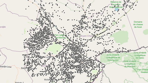
Each year, approximately 6 million of the 20 million children born in West and Central Africa miss out on even one dose the most basic Diphtheria-Tetanus-Pertussis (DTP) life-saving vaccines during their first year of life: the so-called ‘zero-dose children,’ according to a working definition widely adopted by UNICEF, the World Health Organisation (WHO) and GAVI – an alliance of vaccine partners – among others.
Reaching the unreached
The Reach the Unreached initiative, led by UNICEF together with UK humanitarian data charity MapAction, French geospatial charity CartONG and the WorldPop programme at the University of Southampton aimed “to improve child vaccination coverage data by pairing our continuous efforts in strengthening administrative systems and household surveys with innovative AI and frontier data methodologies to provide geolocated vaccination estimates to be used in actionable maps and dashboards” says Niccolo Cirone, Data Specialist, UNICEF Regional Office for West and Central Africa (WCARO).
The goal was to “strengthen immunisation planning in five pilot countries—Cameroon, Chad, Côte d’Ivoire, Guinea, and Mali—by enhancing the use of geospatial data, improving coordination among national stakeholders, and building long-term capacity,” adds MapAction’s Ant Scott.
GIS4Health
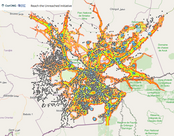
Experts engaged in accessibility analysis might normally consult a national mapping agency or digital road archive to solve such a riddle. In countries where Google Maps is patchy and national mapping agency data is limited or non-existent, the road network needs to be mapped for the dots to connect. This data is limited, often ringfenced in some way, or simply unavailable.
The joint teams trained more than 100 personnel across the five countries: the training, provided to local health ministries, CSOs and stakeholders, focused on generic data and Geographic information Systems (GIS) techniques, as well as the application of tools and methodologies developed during the project.
Closing the gap
The feedback from participants was good and rich in recommendations, partly due to differing levels of previous exposure to GIS technology, mapping and health data. “I’ll use the skills and knowledge acquired to meet the needs of the ministry through the Directorate of Statistics and Health Information,” said one ministry official in Chad following a training workshop in December 2024.
Another ministry employee in Chad added: “This knowledge will allow me to be more effective in estimating the populations of my Areas of Jurisdiction, but above all help in the delimitation of those areas. This knowledge will be of great use to me.”
Ultimately the capacity-building efforts highlighted the need for differentiated training, ensuring that both policymakers and technical teams receive the right level of support.
Data headache
Sourcing the right data, whether for population modelling or mapping roads, can be complex. “There were primarily two big challenges,” says Dr Attila Lazar, with the University of Southampton’s WorldPop programme, a project partner responsible for modelling population data, “accessing the best available demographic data sources and receiving geolocation information with these data. Population data at small area scales is sensitive and multiple approvals are required that can be time consuming, delaying construction of population estimates,” adds Dr Lazar.
The same is true of road data, notes CartONG’s Mathieu Anselmino. “There was simply no data about roads available for the pilot area which is why we used volunteers to source them.” Solutions began to emerge at data harvesting mapathons in Chad using OpenStreetMap (OSM) data to map the Chadian road network late last year.
This led to a greater understanding among relevant government agencies of how important this work is to conclude, as illustrated by this CartONG story map.
An online toolkit was also created to guide participants sustainably through some of the tools and data compiled during the programme.
The impact was tangible. “The Cameroon field teams were able to use our zero dose children population estimates confidently, which led to an increase in over 70,000 zero-dose and 100,000 under-immunized children reached,” says Niccolo Cirone, Data Specialist, UNICEF Regional Office for West and Central Africa (WCARO).
More resources