A web map to better inform and orient migrant populations in Calais
In early 2021, CartONG was approached by the French Red Cross and Refugee Info Bus to create a web map displaying information about the various services provided to refugees present in the area of Calais. This request was handled by a small group of CartONG’s, with the support of the staff team.
A joint effort led by volunteers
Following the training on the open source and collaborative online mapping tool GoGoCarto organized in December 2020 for 11 volunteers, several of them expressed their interest in supporting basic web mapping requests from small and medium-sized organizations. Naturally, upon receiving the request from the French Red Cross and Refugee Info Bus, a group of 3 volunteers was mobilized to take part in this project with the support of one of CartONG’s civic service volunteers.
Two associative actors working in support of migrant people
This volunteer project was carried out in support of two very active associations in Calais: the Dispositif Mobile de Soutien aux Exilé.e.s (DMSE) of the French Red Cross – a mobile program to support exiled populations -, and Refugee Info Bus.
Since February 2016, the French Red Cross has been working with exiled populations present in the informal settlements of the Hauts-de-France region through the DMSE program. It aims to reach out to refugees and is operating in informal settlements to provide support to wandering people, particularly in Calais and Grande-Synthe, by providing access to first aid, transportation on request to the permanent Health Service Access Points, also known as PASS (Permanence d’Accès aux Soins de Santé in French), support and guidance activities, as well as social emergency services, assistance in maintaining or re-establishing family ties, and specific support for juveniles living in exile in the Dunkirk region.
As for Refugee Info Bus, the organization was created in 2016 by a group of active volunteers in the “Calais jungle”. Today, it is a grassroots organization that supports refugees on the move in Northern France by providing practical information on available services as well as access to the Internet and phone recharging. On the ground, Refugee Info Bus teams conduct their activities from a mobile bus. Since summer 2019, the association has been producing information guides in several languages, these are regularly updated for new arrivals in Calais and Dunkirk.
Addressing the need while identifying the constraints and issues
The challenge of this project was to create an accessible web map that would be sustainable in the long run, and that would allow to better locate the different associative services available to refugees in Calais, and eventually to print maps for migrants seeking to be oriented towards the facilities offering such support services.
Refugee Info Bus had already carried out a handwritten inventory of the facilities and organizations currently operating and continued to track regularly their opening hours to ensure they were up to date. The existence of a clear, structured and up-to-date database proved to be a valuable resource for our volunteers. However, these guidebooks in printed format did not allow for a precise location of the organizations operating in the area, nor did they allow for a detailed search by type of organization or by day and opening hours or availability.
“This project of web mapping of the coastline is based on the observation that access to information is lacking in the informal settlements of Hauts-de-France, because of repeated evacuations by the police, but also because of the COVID-19 crisis which has destructured the associative network of the territory” – Anouk Vallette-Philippot, volunteer at the French Red Cross
In order to create a map that would remain relevant over time and be usable by local actors, our team of volunteers also had to think about the map update process. The challenge here was to choose a web mapping tool that could be easily used by a member of Refugee Info Bus (to maintain the info up to date), which explains the final choice of GoGoCarto. Our volunteers thus created an easy-to-use data entry form, trained the person in charge of the update, and created a tutorial to ease this process.
A web map to list the associative services of the coastline
The map is primarily intended for aid workers (employees or volunteers) to facilitate the reception of refugees in Calais and to guide them in the best possible way. Ensuring the map would be easily accessible has raised several challenges for the volunteers involved in its development. Despite the need for exiled people to have access to multilingual information, it was decided not to use a translation feature, as it was too complex to implement on a free web mapping tool. The map was therefore created in English so that English-speaking migrants with access to the Internet could access it online.
“This map, which lists the associative services along the coast, is a valuable tool that will serve as a database in the field to centralize information and disseminate it more easily to people in exile who live/survive in informal settlements. Access to information is a major issue, and this web map will allow us to better accompany the exiled public and respond more effectively to their needs.” – Anouk Vallette-Philippot, French Red Cross volunteer
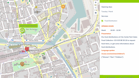
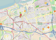
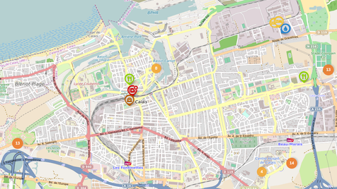
The map currently lists 60 points covering 14 types of services ranging from food distribution to free legal aid to phone charging points. It also lists services for unaccompanied minors as well as services to help re-establish family ties. In Calais, many of the services offered are mobile – which means frequent changes in distribution locations – or do not have regular opening hours or days. GoGoCarto allows for a double sorting by day and by category, which is very useful in this context: for example, one can search for food distributions that take place on Mondays, or health services that are accessible on Sundays.
After selecting a facility, a pop-up window appears displaying the information registered for the said facility: name, address, phone number, list of services offered and opening hours, presentation, languages spoken within the facility, and types of public welcomed (Men, Women, Children).
Anouk Vallette-Philippot, volunteer at the French Red Cross, shares her experience:
“I am very happy with this CartONG – Refugee Info Bus – Red Cross partnership, it allowed us to gain perspective and find a mapping tool that meets our needs in the field. A huge thank you to the entire CartONG’s team for this great mapping adventure!”
A very big thank you to our volunteers Jean-Yves, Jean-Paul and Michel and to Laure, civic service volunteer at CartONG, who took part in this project with great enthusiasm and ingenuity!
—–
This project was funded by the H2H Network’s H2H Fund, which is supported by UK aid from the UK government.
The volunteer training on GoGoCarto was carried out thanks to the financial support of the FDVA (Fonds de Développement de la Vie Associative) of the French Ministry of Education and Youth in Auvergne Rhône-Alpes.
