Mapping services in the Lake Chad Basin for and by youth
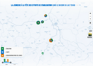
In the spring of 2020, CartONG responded to a call for proposals from Plan International Germany to develop a set of interactive tools to map basic services and causal peace factors in the Lake Chad Basin (Nigeria, Niger and Cameroon) in real time over a 3-year period. The outcome of this project is a public map, available in French and English, which can be accessed online. This project was coordinated by Plan International Germany and implemented by Plan International Cameroon, Niger and Nigeria.
Plan International’s activities in the Lake Chad region
Plan International works in the Lake Chad region as part of the project, “Youth Leading Stabilisations Efforts in The Lake Chad Basin”. It is a multi-country project developed thanks to the support of the European Union, and designed and implemented to support peace and security, and strengthen stabilization efforts in the region across 3 countries: Nigeria, Cameroon, and Niger.
A multi-faceted project
Plan International Germany wished to collect data on 4 basic services and causal peace factors – health, education, youth participation, and youth economic opportunities and livelihoods – in the Lake Chad region and to monitor the evolving presence of these services. For its part, the online public map was meant to only display data specifically related to infrastructures – i.e. the education, health and youth-led organizations – and to be updated twice per year following a general data collection process.
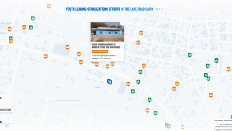
Each type of service is distinguishable by its color and logo. Blue refers to schools or education services, green to health care facilities, and orange to youth-led organizations. A pop-up appears when a service is selected to display more information.
The project was thus built around 2 technical components, each including some specificities at the request of Plan International: (i) implementing the data collection, from the creation of the survey forms to the management of accounts and rights on the mapping platform and the update of the map over the course of the 3 years; and (ii) developing the mapping platform to display the results of the data collection while distinguishing each type of service visually – through the use of different icons and colors – and making available some additional information about each listed service (name, type of infrastructure, and a photo if available). As the mapping project was to be carried out over three years, from 2021 to 2023, the NGO wished to be able to follow the evolution of the services available over the course of the whole project. The map was required to allow comparison between the different data collections over the years – using a filter by year.
Beyond these technical aspects a third, and human-related dimension in line with Plan International’s mandate, was added to the project, namely: iii) youth capacity building.
Mapping with a capacity building approach
A key request of Plan International Germany was to integrate the participation of local youth across the three countries throughout the project. From data collection in the field to the integration of the data into an online mapping platform, each step had to be managed by local youth.
To meet this demand, CartONG’s support was threefold:
- Implementing a mobile data collection by coding the questionnaires using tools which were user-friendly enough for the young data collectors handling them during the 3 years of the project.
- Developing an online mapping platform to display the results of the data collection while remaining easy to use for youth.
- Training of teams in each country to enable young people to take ownership of and maintain the tools put in place during the 3 years of the project.
A continuous adaptation to needs and constraints
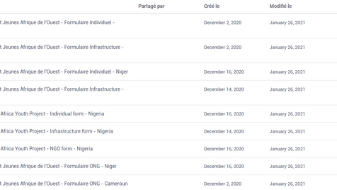
When the project was launched, Plan International’s data collection needs were fairly straightforward and did not raise any particular technical issues. It was therefore decided to develop a single form. After several discussions with the partner organization, the form quickly became more complex with the use of questions targeting three different categories of actors (infrastructure, associations and individuals) and many open-ended questions.
Our teams recommended creating three distinct forms for each of the three targeted groups, and then developing versions for each of the three countries of the project (Cameroon, Niger and Nigeria) so that they could access their own form – in English or in French, depending on the main language of the country. This choice was driven by the necessity of not mixing the data collected about different topics and from different countries in order to ease the collection and update of the map.
To ensure that each country’s team would have full control over its own data and to make it easier to manage the system, we also decided to divide the user accounts in KoBoToolbox by country.
Administration on KoBoToolbox
Once the different questionnaires had been developed, different user accounts were created on the KoBoToolbox server so that the data collected by the youth could be loaded into the tool. The objective was to define different types of users in order to grant them distinct access rights. The collector’s accounts allow the data to be uploaded to the server so that they can later be reviewed and approved by the survey managers.
Choosing the mapping platform also led to several discussions to ensure the tool respected both the project’s requirements for the map and the technical constraints inherent to the use of KoBoToolbox. Our teams initially suggested using uMap, an open-source and easy-to-use mapping tool. However, we quickly faced technical constraints, especially regarding the connection between KoBoToolbox and uMap. This constraint could only be circumvented by a succession of manual steps to import the data from KoBoToolbox. Given the project’s focus on youth capacity building, such a solution seemed inadequate without having prior knowledge of the youth’s technical skills level for these tools.
We eventually chose to develop this mapping platform ourselves with Javascript in order to meet Plan International’s needs as precisely as possible. The map, hosted on GitHub, is updated automatically since it calls directly the data from the KoboToolbox API, previously approved by the youth in KoboToolbox. A solution that perfectly meets Plan International’s needs and allows young people to embark on the project since no other data import step is required.
Our support was wrapped up with a 2-day online training for each of the 3 countries to impart the required skills for them to become operational with the tools. Each training session gathered around 15 participants and was designed to train both groups of trainers and young people who would, in turn, train several youth teams in charge of data collection and so they could be in control of the whole process – from data collection to data visualization on the mapping platform. They thus focused on the use of ODK Collect, the application used for data collection, as well as on data extraction and validation on KoBoToolbox.
A successful capacity-building process and new map developments
Building the capacity of our partners and ensuring an adequate appropriation of the tools developed as part of a given project, are both key objectives for CartONG. This project with Plan International was a great opportunity to put this dimension of empowerment and tool appropriation at the heart of our work while taking into account a new component for our teams, namely the participation of local youth in the project.
“For the multi-country project “Youth Leading Stabilisations effort in the Lake Chad Basin” implemented by Plan International Germany in Cameroon, Niger and Nigeria and funded by the European Union, it has been very important to have the support of CartONG in the development of this user-friendly map-based platform on which young people can map and monitor 4 basic services and causal peace factors (health, education, youth economic opportunities, and Livelihoods and youth participation). We would also like to emphasize that the development of the map-based platform followed the Principles for Digital Development, mainly design with the user, understanding the existing ecosystem, using open standards, and reusing and improving; this will allow us to update and improve the map-based platform when necessary.” – Paula Blanco Alvarado, Programme Specialist Plan International West Africa
This was also an opportunity for CartONG to work on a project bringing together several of its areas of expertise. Our teams specialized in mapping, Mobile Data Collection and web development worked together throughout the project to fully meet Plan International Germany’s needs.
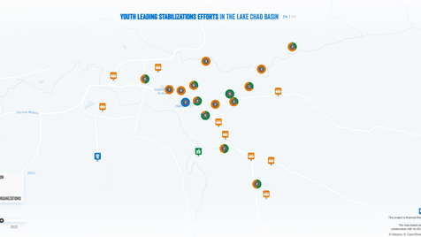
Since the first launch of the map-based platform in May 2021, our team has been contacted again by Plan International to develop two new features: it is now possible to switch for a satellite view of the map and also have a “cluster” view when several services are located in proximity to one another. The clusters show both the total number of services belonging to the cluster and the proportion of each type of service within the cluster. That way, Plan International Germany and the users of the map can see, at a glance, which types of services are most represented in which geographical areas.
This mapping project will be ongoing for 3 years and we can’t wait to see the map getting filled in, proof of a successful autonomization!