A look back at CartONG’s participation in the GeoNight 2023!

What is the GeoNight?
The GeoNight was created in France in 2017 by the French National Committee of Geography (CNFG). It has since expanded to Europe and then to the international level. Its goal? To showcase geography and geographers once a year and give the general public the opportunity to learn about geographic concepts and studies. Find out more here.
Mapathons for the SDGs
“The event was a great success in Togo and allowed us to complete the mapping of 3 projects. We had 37 participants, 23 in person and 14 online, most of them new contributors. The participants were very happy to take part in the event and most of them want to join us and be part of our community.” – Feedback from OSM Togo who co-organized a mapathon in Lomé
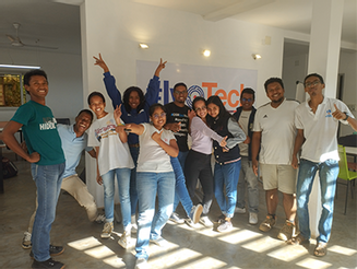
Mapping areas that do not appear on maps: this is the basic objective of a mapathon. From remote or in person, experienced cartographers and amateurs with a passion for geography came together to produce geographic data on the OpenStreetMap (OSM) platform, the Wikipedia of maps. This data will facilitate the activities of various actors working in line with the Sustainable Development Goals (SDGs) in Togo, Benin and Madagascar. In collaboration with local OSM communities, we decided to map territories in these three countries, where projects for the promotion of peace and security (SDG #16) and sustainable local community planning and development (SDG #11) are underway!
For example, some of the participants were able to allow Djeregou and Konohoué, two villages located in Togo, to appear on the OpenStreetMap when there was almost no data before. Others have mobilized in the Betsiboka region of northern Madagascar to map buildings located near the Maevatanàna water bodies and thus allow actors on the ground to better plan for risks related to development in this flood-prone area.
In total, 8 field projects have been supported, that is 8 towns and villages that now appear on the map!
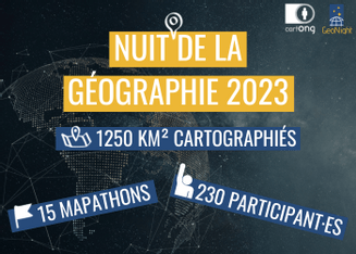
Through 15 mapathons (8 in France, 6 in French-speaking Africa and 1 online), more than 44,000 buildings were mapped thanks to the mobilization of more than 230 participants, representing more than 420 hours of collective mapping. This first step will be completed by a validation of the data in the field by the local OSM communities. Discover the story map created for the occasion and find the details of each of these mapathons!
Thank you all!
Thank you to the participants for coming together and taking part in this event. Whether you are a geography enthusiast, an experienced cartographer or a novice, your participation was precious and we loved meeting you and sharing this moment together.
“A very big thank you from the Sorbonne and Lycee Dorian for organizing the GeoNight mapathon. The feedback from the students who participated was excellent and we look forward to repeating the experience next year.” – Feedback from the Sorbonne and Lycée Dorian who hosted a mapathon in Paris
We would particularly like to thank the 16 partner organizations without whom this GeoNight could not have taken place.
See you next year for a 2024 edition that we hope will be even more successful to continue to fill the world map!
This initiative is part of Mindchangers’ project. This publication was produced with the financial support of the European Union, through RESACOOP within Mindchangers – Regions and youth for Planet and People. Its contents are the sole responsibility of CartONG and do not necessarily reflect the views of the European Union.