A partnership in support of humanitarian action: CartONG & Médecins Sans Frontières
About
Description
Over the past decade, the CartONG–MSF partnership has transformed the role of GIS within humanitarian operations. Launched in 2013, this collaboration has contributed to structuring, professionalising, and expanding MSF’s capacity in Geographic Information Systems (GIS), ultimately leading to the creation of the GIS Center: an internal service dedicated to cartographic production in support of field operations across the various countries where the movement operates.
Today, the GIS Center continues to evolve, driven by the complementary expertise of CartONG and MSF teams, to address emerging challenges such as the growing number of crises, increasingly complex operational environments, rising data volumes, and the diversification of digital tools. This article looks back at a partnership that has been instrumental for CartONG.
CartONG, a key player in the creation of MSF’s GIS Center
At the outset of the collaboration, MSF primarily relied on external maps and did not yet have a dedicated internal service. CartONG played a decisive role in the evolution of this approach by:
- supporting MSF in structuring a genuine internal cartographic production capacity,
- contributing to the establishment of a cross-cutting GIS department, which would later become the GIS Center.
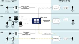
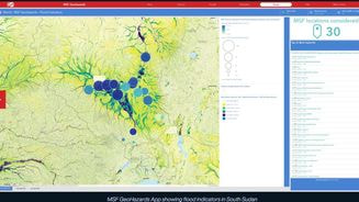
In parallel, CartONG designed and developed major tools such as the Map Centre, an online platform providing access to all geographic products used by MSF—static maps, interactive GeoApps, monitoring and analysis tools—both at headquarters and in the field.
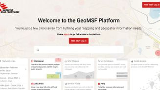
This tool—now known as the GeoMSF Platform—has become the backbone of geospatial information management for MSF teams.
A partnership serving operations: mapping, analysis, and digital tools
Over the years, CartONG has supported MSF missions across a wide range of humanitarian contexts, including:
- refugee camp management,
- epidemic responses (Ebola, cholera),
- contextual and security monitoring,
- logistics and operational planning.
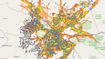
Concrete initiatives such as the GIS infrastructure deployed in Bangladesh, the mapping of the Bidibidi camp in Uganda, or field-based training missions illustrate both the diversity of needs addressed and the close collaboration between MSF teams and CartONG GIS specialists.
The essential role of today’s teams within MSF’s GIS Center
Today, the GIS Center teams—of which CartONG remains a key contributor across several areas—focus their work around three main pillars:
1. Cartographic production
The GIS Center centralises and processes map requests from field missions and operational departments. Teams produce:
- reference maps,
- epidemiological maps,
- logistical maps,
- advanced geospatial analyses.
This service has become part of the daily operational toolkit, supporting emergency responses, inter-Operational Centre coordination, and operational decision-making.
Explore the StoryMaps CartONG contributed to:
2. Learning & Development
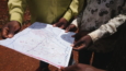
Often less visible, training efforts are nonetheless essential for building the capacity of field teams. Training missions organised by the GIS Center and supported by CartONG—such as those conducted in 2023 to strengthen team capacities in East Africa—help harmonise GIS practices, improve data management, and foster greater autonomy among operational teams.
3. Data Management
The partnership has enabled the implementation of robust geospatial data management methods. Today, the GIS Center:
- structures data repositories,
- improves the quality of data collected in the field,
- supports the integration of data from crowdsourcing initiatives (e.g. Missing Maps) and satellite imagery,
- ensures consistency of GIS workflows across MSF’s different Operational Centres (OCs).
These advances directly support the quality of analyses produced and the speed of responses to humanitarian crises.