QGIS training in the field of migration
About
Description
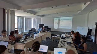
CartONG conducted a one-week field mission in Ankara, Turkey, in support of the NGO SGDD-ASAM, which works in the field of migration and support to the internally displaced people in Turkey following the February 2023 earthquake. The aim of this project was to:
- Provide a training to ASAM specialized M&E staff on GIS and mapping basics (including training preparation, post-training support and project closure)
- On-site needs assessment and infrastructure set-up assessment

The training covered basic GIS principles and theory with a focus on QGIS, a GIS open source tool that met SGDD-ASAM’s needs. This tool, beyond being open-source and free, also has the advantage of interoperability with other systems and tools, which was in line with SGDD-ASAM’s needs since they used different tools such as Microsoft SQL server, as well as Excel and Kobo for data collection in the field. Some of the topics covered during the training were: GIS Introduction & GIS Concepts, QGIS configuration & data, Symbology and labels, Data creation, Data join, Advanced symbology, Map design and layout, OpenStreetMap data. During the second part of the training, participants had the opportunity to practice through exercises specifically created for the NGO’s context using their own dataset, the same that would then be used in their day-to-day operations, covering topics such as: Ramp colour, Proportional circle, Diagrams, Flow Map, Heat Map, Labels and conditional label (size and style).
As with all training courses, CartONG also provided an up-to-date step-by-step guide with all the QGIS features covered during the training, as well as a set of recommendations based on the assessment of SGDD-ASAM’s datasets and data management practices. This training also opened new collaboration avenues between CartONG and SGDD-ASAM related in particular to web mapping through the Lizmap tool.
