Webmapping for small and medium-sized community organizations
In the midst of the Covid-19 health crisis, CartONG’s volunteers accompanied many national and international solidarity organizations throughout 2020, particularly by providing web mapping support. During the past year, our volunteers were trained to use several free and open source web mapping tools. This capacity building effort was carried out in response to requests from our partners – in particular small and medium-sized organizations which needed to create interactive online maps that are simple to use and easy to update; but also to provide online training for our volunteers. What’s more, we also wanted to share this experience with other actors in the social and aid sectors by publishing a benchmarking of online interactive mapping solutions.
Two major web mapping projects led by volunteers
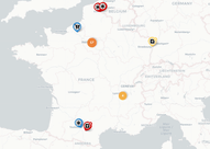
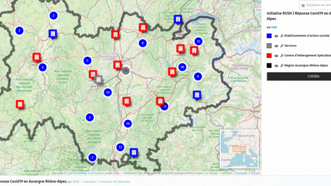
A first web mapping project started in March 2020, following a request from the RUSH initiative (“Réponse d’Urgence Sociale-Humanitaire” or Emergency Social-Humanitarian Response in the Auvergne-Rhône-Alpes region). Two CartONG volunteers worked on the creation of a web map developed on uMap (a free tool created by the OpenStreetMap community) allowing to match the urgent needs in humanitarian actors of social organizations facing a lack of staff or volunteers in the context of the health crisis – and the profiles of available humanitarian professionals, according to their location and skill set.
A second project aiming at producing the #DiasporaAgainstCovid map was conducted between June and December 2020 within the framework of the IM Covid-19 Help Center set up by CartONG with the support of the H2H Network and the French Development Agency (more details below). This project aimed at providing web mapping support to FORIM (Forum of International Solidarity Organizations stemming for Migrations), a French platform that brings together more than 1,000 OSIMs (International Solidarity Organizations stemming for Migrations), involved in social inclusion and development actions. During the health crisis, many projects were implemented by OSIMs, both in France and in the countries of origin of the people involved in these organizations.
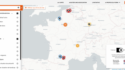
In June, a CartONG volunteer launched the creation of a map developed on GoGoCarto (an open source collaborative mapping tool developed by the COmmunecter community), which identifies and promotes the various solidarity actions of OSIMs, such as the distribution of hand-washing kits and masks in Togo, or the distribution of food to foreign students and migrant workers in Rouen.
Adding information onto the map and updating it was made easier by adding an embedded form, a key feature that contributed to the fact GoGoCarto was chosen for this initiative. In fact, member associations of FORIM can first submit examples of actions to be added to the online map, by filling in a list of key information (name and description of the association that carried out the action, area of intervention, type and number of beneficiaries, description of the action carried out, cost and partners). The information is then verified by an administrator member of the FORIM’s network, before being approved and published on the online map. This two-step process has the advantage of allowing the direct contribution of numerous actors to the interactive map, while ensuring the quality of the data presented to the public.
The map – see opposite – helps to enhance the role of diasporas in a context of crisis and was published by FORIM on December 18, 2020 also known as International Migrants Day.
Pierangela Fontana, Head of Communication, Campaigns and Events at FORIM, reflects on this experience:
“It was very enlightening, both from a human and training point of view. The volunteers of CartONG worked closely with FORIM, and provided very professional support, with commitment and enthusiasm. I really appreciated the mutual sharing of skills and knowledge. This map is a real tool of valorization and communication that enables us to appreciate the richness and diversity of the contributions made by associations resulting from migrations in a context of social and health crisis,
both in France and in the countries of origin”.
Release of a benchmarking of interactive online mapping solutions
As part of this second project, a group of CartONG’s volunteers and staff set out to publish a benchmarking of online interactive mapping solutions for beginners in the fall of 2020. The purpose of such a technical resource? To help people with limited web mapping skills choose a tool adapted to their needs among four easy-to-use tools: namely, GoGoCarto, Ushahidi (which our staff team had also previously used on a project in 2020, the Open map of the global pause, on the positive effects of lockdown worldwide), uMap, and Google My Maps, by giving an overview of the main advantages and disadvantages of each of these tools.
Building capacity among our volunteer’s community through online training
Following these first two projects, CartONG decided to organize an online training on the free and collaborative web mapping tool GoGoCarto for its volunteers; a tool with many functionalities, which meets rather well the needs of small solidarity organizations. On Saturday December 5th, 11 volunteers were thus trained by a staff of CartONG.
Following this training, several volunteers have embarked on a new volunteer-led project: as a matter of fact, they are currently working on a GoGoCarto map in support of Calais Red Cross and Refugee Info Bus, to help migrants based in Calais better navigate the area. A great way to put into practice the skills acquired during the training!
Thank you to our donors and partners!
The #DiasporaAgainstCovid map as well as the benchmarking of online mapping tools took place in the framework of the Covid-19 IM Help Center, supported by the French Development Agency and the H2H Network’s H2H Fund, the latter supported by UK aid from the UK government.
The volunteer training was carried out thanks to the financial support of the FDVA (Fonds de Développement de la Vie Associative) of the French Ministry of Education and Youth in Auvergne Rhône-Alpes.
Are you part of a small or medium-sized social or aid organization that would like to receive support for the creation of an online interactive map? Feel free to contact us to discuss your current needs.
