An interactive map to shed light on SOS Méditerranée’s rescue operations
Used every year by tens of thousands of people fleeing war, violence, poverty and difficult living conditions, the Central Mediterranean is one of the main migratory routes. It is also one of the deadliest, with an average of 2,800 human losses or disappearances each year since 2015 (source UNHCR). Behind these figures lies a reality, and this is where humanitarian organizations, such as SOS Méditerranée, step in, to reduce this figure and rescue anyone in distress in the Mediterranean. These rescue operations are vital, though often unrecognized and criminalized.
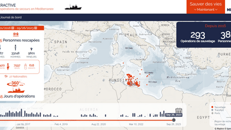
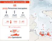
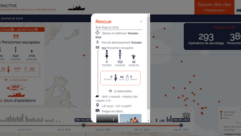
The interactive map uses dots to indicate the precise location of each operation. Visitors can find out more by clicking on a point to display a summary sheet containing crucial information about the operation. This includes the date of the operation, the type of boat rescued, the number and type of people rescued, the port of disembarkation, and even multimedia content (photos and videos) that bears witness to the reality of these operations. The dashboard also allows users to search for specific operations or a series of operations over a given period, using filters integrated into the timeline and map legend. This dashboard gives anyone, whatever their level of interest or knowledge, easy access to essential information on the progress of the NGO’s rescue operations. By providing factual data, it reinforces the organization’s transparency and helps to resist misinformation by setting the record straight on each operation.
This support has enabled us to create a new tool that would not have been possible without external support. This new tool brings real added value to reinforce our transparency, develop the pedagogy around our activities and will serve to support our institutional advocacy
The SOS Méditerranée team talking about CartONG’s support
A particularly important project for CartONG, not only because of the final objective, but also because it is the first web development project carried out entirely by a team of volunteers, with occasional support from two CartONG salaried web developers. “The completion of this project demonstrates the commitment of our volunteer community, their high level of technical skills and their willingness to invest in long-term projects,” confirms Clara Castoldi, CartONG’s Volunteering and Partnerships Manager during the implementation of the project. For some volunteers, the project was also an opportunity to enhance their skills, learn about technologies they didn’t initially master, and thus become proficient in the use of new tools for implementing similar projects in the future. “This project has shown us once again the potential of the CartONG team of volunteers, a competent and committed team, which enables CartONG to broaden the range of support offered to humanitarian and development organizations,” continues Clara.
This interactive map doesn’t just represent data; it testifies to the authenticity of the actions of those who defend life in the Mediterranean Sea. A project which adds to the various types of mapping support already provided by the CartONG volunteer community to a large number of organizations over several years, and which initiates a closer collaboration with SOS Méditerranée for the near future.
