Mapping for SOS Méditerranée sea rescues
About
Description
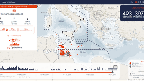
A CartONG volunteer team has created a dashboard with an interactive map that offers an intuitive approach to exploring the details of SOS Méditerranée’s sea rescue operations.
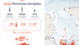
An interactive map shows the precise locations of each operation, allowing users to click on points to access summary sheets containing information such as the date of the operation, the type of boat rescued, the number and type of people rescued, the port of disembarkation, as well as multimedia content bearing witness to the reality of these operations.
Search functions enable users to find specific operations or a series of operations over a given period, reinforcing the organization’s transparency and helping to combat misinformation by re-establishing the truth about each rescue operation.
This project is of particular importance to CartONG, as it is the first web development project to be carried out entirely by a team of volunteers, with occasional support from salaried web developers. It demonstrates the commitment and high technical skills of CartONG’s volunteer community, while offering volunteers the opportunity to improve their skills and familiarize themselves with new technologies.
In conclusion, this interactive dashboard represents a crucial step in the fight against misinformation and for the transparency of the sea rescue operations carried out by SOS Méditerranée. It testifies to the authenticity of the actions of the defenders of life in the Mediterranean, and marked the beginning of a closer collaboration between CartONG and SOS Méditerranée.