Humanitarian crisis in Ukraine
About
Description
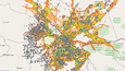
CartONG deployed two Geographic Information Systems (GIS) specialists as part of the MSF GIS Centre team to support the 5 Operational Centres of Médecins Sans Frontières (MSF) in Ukraine from mid-April to mid-June 2022. The GIS specialists were responsible for locating and qualifying activities, translating them into static or dynamic forms, and managing spatial data to ensure efficient and up-to-date support.
An initial 5-week mission between Poland and Ukraine was led by a GIS & Database Specialist, followed by a second 4-week mission by a Mapping & GIS Specialist in Ukraine. The first mission focused on centralizing and structuring data related to the ongoing war in Ukraine, making it visible and accessible to operational teams through static or dynamic maps (geoapps). These GIS products facilitated decision-making in the field for MSF coordination in the implementation of specific projects or activities, and guided the overall strategies of action and deployment. The team produced over 15 static maps on ArcGIS Pro and 4 online applications on Portal within 5 weeks, while developing robust data management and processing workflows.
The second mission, from mid-May to mid-June 2022, included project visits over the country and aimed to increase the support to the project team and finetune some specific products. The team maintained existing tools, developed new ones, and trained field teams to use them. The documentation work was done, and support was provided for the recruitment of a national GIS specialist to stabilize the handling of GIS needs on-site. Due to the crisis situation, access to project teams was sometimes challenging, and projects were scattered, requiring complicated logistics. To address these challenges, the team decided to revert back to a “GIS duo” by combining the data component with the mapping one.
After these two deployments, the remote support to the team on the ground resumed. This was focused mainly on supporting the recently recruited Specialists in the country until the GIS Specialist was autonomous in the support of the project team.