
Remote sensing for environmental assessments
About
Description
A team of CartONG staff and volunteers supported Solidarité International (SI) in their Environmental Impact Assessment (EIA) in Myanmar by providing them with a set of maps produced using remote sensing techniques.
The purpose of the Environmental Impact Assessment was to measure the environmental vulnerability and possible mitigation measures to be considered by Solidarité International (SI) while implementing WASH (Water, Sanitation and Hygiene) and FSL (Food Security and Livelihoods) activities.
Solidarités International required maps for two different areas. First, the flooded areas of Bhamo Township where the organization was implementing FSL activities in support of local farmers. In particular, land cover and land use maps – some of which specifically showed forest cover and/or sandy areas – as well as flood maps. Maps were also requested for Momauk Township where SI was implementing WASH activities, particularly in the Internally Displaced People (IDP) camps in Lwegel town. For this area, priority was given to land cover and land use maps, including forest, agricultural and urban areas amongst other elements.
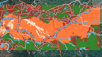
During the evaluation phase of the cartographic products to be produced, the starting point was the products clearly identified by SI before the project. The volunteers then evaluated the available data and the various remote sensing analysis methods, resulting in a wider range of products than originally envisaged by SI. As such, the volunteers not only look at how to produce maps of land cover and land use and maps of flood zones but also at maps of deforestation, maps of pollution as well as maps illustrating the high human concentration in the targeted areas.
The satellite images are from the Sentinel satellites, a family of Earth observation satellites and instruments from the European Space Agency. They form the space component of the European Union’s Copernicus program. In terms of software, the CartONG volunteers used mainly open source tools for this project: in particular QGIS. Land use is characterized by a supervised classification under the R programming language. As for the floods, they were determined using SNAP and Visan software (as would be the case for pollution maps, for example).
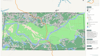
In the end, our team produced 5 maps for the Bhamo and Momauk townships – including a flood map, two maps of land cover and land use, and two maps of forest cover and sandy areas.