10 years of partnership between CartONG and the MSF GIS Centre
How everything started
The partnership between CartONG and the Doctors Without Borders (MSF) GIS Centre began in 2013 when CartONG proactively supported MSF Switzerland with the production of maps on various emergencies that year. It then evolved to eventually include field missions from 2014; ongoing support and responsiveness that delivered relevant geospatial solutions within tight deadlines.
Beyond emergency response, CartONG has considerably contributed to structuring MSF’s GIS workstream. In particular, our teams have collaborated since 2015 on defining the various strategies of the GIS Centre as well as developing the MapCentre platform and then the GeoMsf Platform, central to MSF for map sharing.
Other services were then developed, including the training of GIS Specialists in the field and the development of complex cartographic outputs such as mobile applications for epidemiological monitoring. This collaboration has made it possible to train local teams and establish solid practices in operational cartography, strengthening MSF’s ability to make effective use of geographic data in its humanitarian operations.
« The collaboration between MSF and CartONG since 2013 has been rich in a diversity of contributions, the nature of which has evolved according to MSF’s needs and the development of both organizations in GIS. In addition to providing expertise and production capacity in cartography, the partnership has enabled mutual fertilization both in terms of strategic thinking and technical subjects, and in terms of structuring the field within our organizations. Other contributions have complemented this core activity, such as the mobilization of field specialists within the MSF GIS Centre team, support in terms of communication and knowledge management, the co-organization of GIS events within MSF, and many others. This year, we celebrate 10 years of collaboration, which has enabled both organizations to flourish in their respective roles, to develop beyond what was initially conceivable, and above all to provide concrete and appropriate support for MSF’s humanitarian action in the field », Mathieu Soupart, MSF GIS Centre, about the partnership with CartONG.
The collaboration between CartONG and the MSF GIS Centre on the ground
Armed conflicts, epidemiological emergencies or natural disasters, the partnership between CartONG and the MSF GIS Centre has played an important role in responding to major humanitarian crises, both in the field and remotely.
In 2014, when the first cases of Ebola emerged in West Africa, a rapid response was essential.
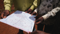
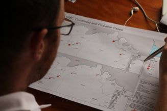
A CartONG GIS specialist was deployed as part of the MSF’s GIS Centre team in Guinea to map an under-mapped region, creating 109 maps thanks to the mobilization of our volunteers: base maps showing roads and villages, as well as specialized maps to track population density and the spread of the disease.
This mission was crucial to understanding and containing the epidemic, particularly in areas such as Gueckedou, where no maps previously existed. The collaboration continued with 18 missions as part of the MSF GIS Centre team between 2014 and 2015, providing essential support to MSF in monitoring the epidemiology.
In 2017, during the Rohingya crisis in Bangladesh, CartONG deployed a GIS specialist to support MSF France in sustaining its GIS activities in post-emergency refugee camps. The mission involved revising the data system architecture, standardizing databases, and recruiting local GIS staff.
In 2022, during the conflict in Ukraine, two CartONG GIS specialists were deployed in the field as part of the MSF GIS Centre team. One of the activities was to map the location of bombings in real time and cross-reference this data with MSF’s activities, to facilitate informed decision-making and intervention planning. Even remotely, CartONG was a valuable partner, particularly during the COVID-19 pandemic, developing a daily updated dashboard that displayed travel restrictions, quarantine measures by country, international airport statuses, and MSF’s logistical constraints.
« Having the opportunity to be deployed alongside MSF teams only makes our partnership with the GIS Centre all the more relevant. Working in contact with field teams is always more effective, because we can immediately move towards more specific and precise GIS needs. This is not only because we can get our hands on the data, but also because we can better understand what is being done with it on each project. These field experiences are very formative, and we always come back with suggestions for improvements to our outputs or working methods.».
Gilles, geomatician at CartONG
The importance of the partnership for the present and the future
« The partnership between CartONG and the MSF GIS Centre has been a driving force behind CartONG’s growth. This growth is intimately linked to that of the MSF GIS Centre, and has had a significant impact on CartONG’s capabilities and service offer.».
Sophie Oddo, Portfolio Manager at CartONG.
MSF’s growing demand has prompted CartONG to expand its offer from static to dynamic mapping, to complex customized solutions requiring web development skills. CartONG team members have also held a variety of positions within the projects – cartographer, developer, trainer, Product Owner, business analyst, data manager, and technical referent. This variety of roles has strengthened the organization’s expertise in different areas related to geographic data, which has been invaluable in meeting the varied needs of MSF and other humanitarian organizations.
This partnership has enabled CartONG to develop essential expertise in operational mapping, diversify its solutions, and play a versatile role within projects, while meeting the complex and changing needs of humanitarian operations.
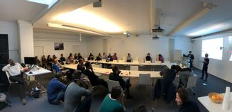
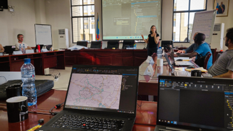
In recent years, as part of the extension of the MSF GIS Centre’s mandate to the entire MSF Movement, CartONG has increased its support to MSF’s 5 Operational Centres in the training of both field and headquarters staff. The use of geospatial data in decision-making has become a crucial issue. Now more than ever, it is essential to raise awareness and enhance the skills of mission managers and Program Managers in these areas, in order to facilitate their work. Our teams recently supported the appointment of a new GIS Specialist in Kenya for MSF Switzerland.
Pascaline, geomatician at CartONG, training MSF staff in Kinshasa, May 2023

