Participatory mapping for food security
About
Description
CartONG and OpenStreetMap Madagascar partnered to support Secours Islamique France’s Avotia project, funded by the French Development Agency, which focused on food security in Southwest Madagascar. The goal was to assess needs, collect field data, produce maps, provide training, and raise awareness. Due to the Covid-19 pandemic the project had to be implemented in six months instead of 2 years. It involved mainly remote mapping during mapathons, training for geography students at the University of Toliara to map their territory and two field missions.
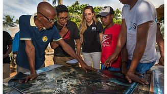
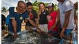
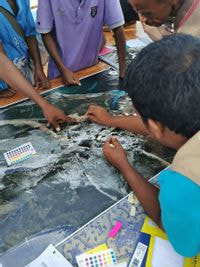
In December 2021, a first field mission aimed to establish an OSM community by training University of Toliara students and assessing the needs of SIF’s team in Morombe. In early 2022, using the needs assessment from the first deployment, we implemented a new methodology during a second field mission combining OSM field data collection and participatory satellite imagery workshops with local stakeholders.
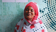
The data collection was conducted with 6 students from the University of Toliara trained on OSM during the first mission. This allowed us to complete a comprehensive mapping of 6 small towns’ infrastructures and some of the agricultural activities – amongst others – conducted by the local communities. The first maps delivered following the mapping sessions were then presented during a workshop with various organizations in Antananarivo.
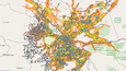
In summary, the data collection involved the integration of 516 points on six municipalities into OpenStreetMap, providing a quantitative and qualitative contribution to the territory. This data was useful to development agencies, governmental organizations, tourists, and visitors. Team workshops were held to raise awareness about mapping and the importance of the local population as a direct source of information. Participants contributed to three maps: activity types, crops and hydrography, and food dependency systems. The completed maps produced dense and comprehensive material, with participants taking ownership of the methodology and incorporating their field expertise. After the second mission, 19 final maps were produced, grouping information on six communes by type, district level, and feedback on food dependency.